Malta has binding commitments to protect a portion of its sea waters, and international sources indicate that these commitments have not been adequately fulfilled. Meanwhile, listening to ministers’ and authorities’ repeated statements on the matter creates an impression that Malta’s marine protection coverage is impressive.
The EU’s Biodiversity Strategy contains a target of protecting 30% of the EU’s seas. Officials say that Malta is currently protecting about a third of its waters. International sources show much lower numbers, under 10%.
What’s behind the discrepancy?
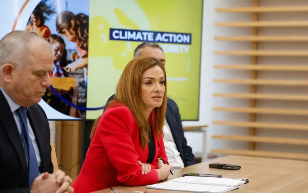
In a recent statement at an international event, Environment Minister Miriam Dalli said that “Malta protects more than 30% of its maritime zone, through Natura 2000 sites, scientific monitoring, and a €2 million conservation programme.”
The Environment & Resources Authority (ERA) also made claims in 2021 that it “designated over 35% of Malta’s waters as Marine Protected Areas.” Ambjent Malta, a government department, also cites the same figure.
In June, Alicia Bugeja Said, Parliamentary Secretary for Fisheries, Aquaculture, and Animal Rights, referenced the over 30% figure of the Fisheries Management Zone as protected areas in a speech.
Meanwhile, the EU’s Biodiversity Information System for Europe (BISE) states that only 5.5% of Malta’s marine waters are covered by protected areas.
The same figure appears on a dashboard managed by the EU’s Joint Research Centre. The UN Environment Programme’s Protected Planet website uses yet another figure: 7.83%. The same figure is used by the Marine Conservation Institute.
This major discrepancy can make it confusing to understand whether Malta is on track with its marine protection targets.
Although the government and international sources roughly agree on the size of Malta’s protected areas, they divide this figure by different reference areas. In mathematical terms, they use different denominators. The smaller the denominator (the territory by which the protected area’s size is divided), the larger the result of the division will be.

How does Malta protect its sea?
Marine territory can be protected under the Natura 2000 and/or national frameworks. The BISE website shows that the two largely overlap.
The designated territories aim to protect specific habitats and species. Natura 2000 sites are not nature reserves – human activities like fishing or tourism are allowed, as long as protected species remain in good condition.
Protection coverage of what, exactly?
In her recent statement, Minister Dalli quoted an audit that said that more than 30% of Malta’s ‘maritime zone’ is protected.
Both Ambjent Malta and ERA use the Fisheries Management Zone (FMZ) as the denominator.
The EU’s Marine Strategy Framework Directive defines a country’s marine waters as coastal waters and “waters, the seabed and subsoil on the seaward side of the baseline from which the extent of territorial waters is measured extending to the outmost reach of the area where a Member State has and/or exercises jurisdictional rights, in accordance with the Unclos [United Nations Convention on the Law of the Sea]”.
This UN convention provides the following definitions:
- Territorial sea – up to a limit not exceeding 12 nautical miles, making it the smallest unit;
- Contiguous zone – up to 24 nautical miles from the baselines from which the breadth of the territorial sea is measured;
- Exclusive economic zone, adjacent to the territorial sea – up to 200 nautical miles from the baselines from which the breadth of the territorial sea is measured.
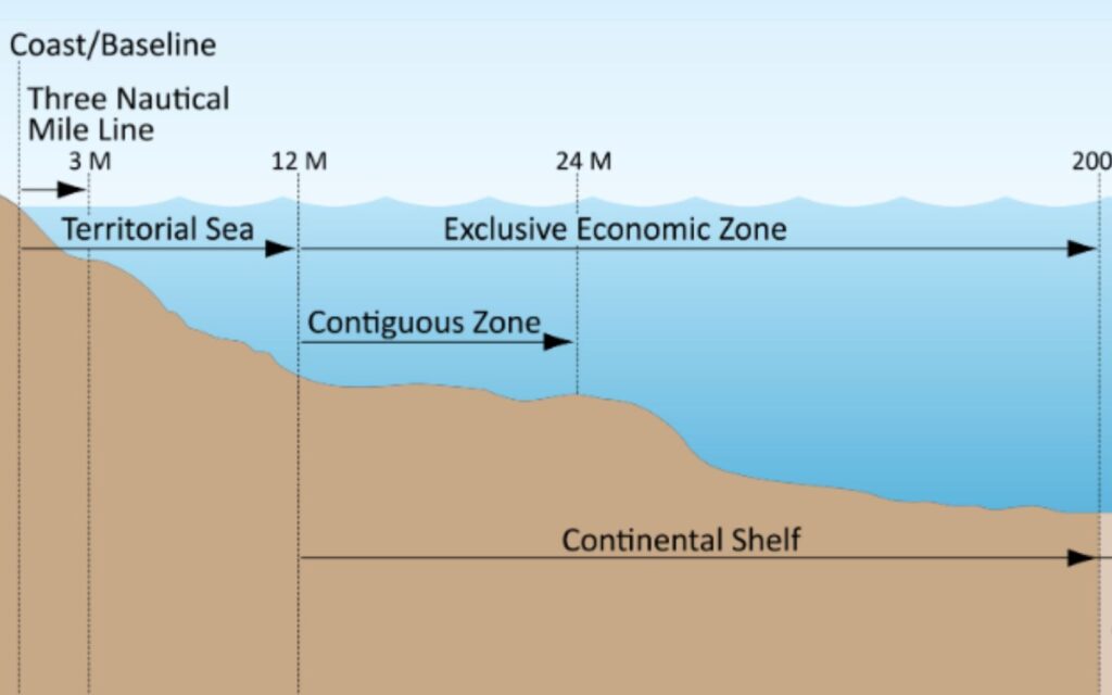
The convention further defines that in the exclusive economic zone, the coastal State has jurisdiction with regard to the protection and preservation of the marine environment.
Malta’s environmental jurisdiction in this zone is confirmed by the Exclusive Economic Zone Act. The UN’s Protected Planet website, the Marine Conservation Institute and the Marine Regions website consider that Malta’s exclusive economic zone is just under 53,000 km², but EU websites state it is over 75,000km².
ERA’s spokesperson questions the use of exclusive economic zone for these calculations. “The [EU-wide] assessments citing 5.5% follow a much broader definition of “marine waters”, which makes the extensive Maltese MPA [marine protected areas] network look far smaller in percentage terms,” the spokesperson explained in response to Amphora’s questions.
In a research paper, the University of Malta’s marine geologist Aaron Micallef has called Malta’s large continental shelf, which is the size of the exclusive economic zone, “Malta’s largest single natural resource”.
However, when it comes to calculating the extent of protection, he shares ERA’s view. “For the purpose of evaluating national protection targets under strategies like the EU Biodiversity Strategy or the Kunming-Montreal Global Biodiversity Framework, the FMZ-based denominator is likely more appropriate, because it reflects Malta’s actual capacity and legal mandate to implement conservation measures,” he said.
The Kunming-Montreal Global Biodiversity Framework is a UN framework. It sets a target to “Conserve 30% of Land, Waters and Seas”. Here, countries submit their own targets, and Malta’s target reflects the language of Malta’s National Biodiversity Strategy and Action Plan to 2030:
“By 2030, 30% of Maltese land and 30% of the Maltese Fisheries Management Zone (FMZ) are legally protected and form part of the comprehensive and ecologically representative National Ecological Network.”
In comparison, Croatia sets the target as “By 2030, protect 30% of marine areas under national jurisdiction.” The Spanish target mentions alignment with EU strategies and aims to protect 30% of the country’s marine surface. Italy speaks of “marine area under Italian jurisdiction” and France speaks of “maritime areas”.
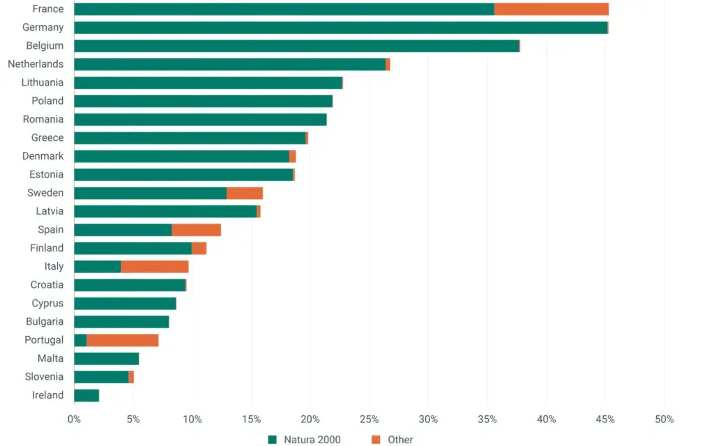
Ireland, which also has a large marine area, has the lowest protection coverage in the EU, and Malta is third-worst performer.
What is the protected area?
Government sources state that the area of the “FMZ is approximately 11,480 km²”. Malta has managed this extended fisheries zone, measured at 25 nautical miles outwards, since 1971. This is larger than the contiguous zone, but much smaller than the exclusive economic zone.
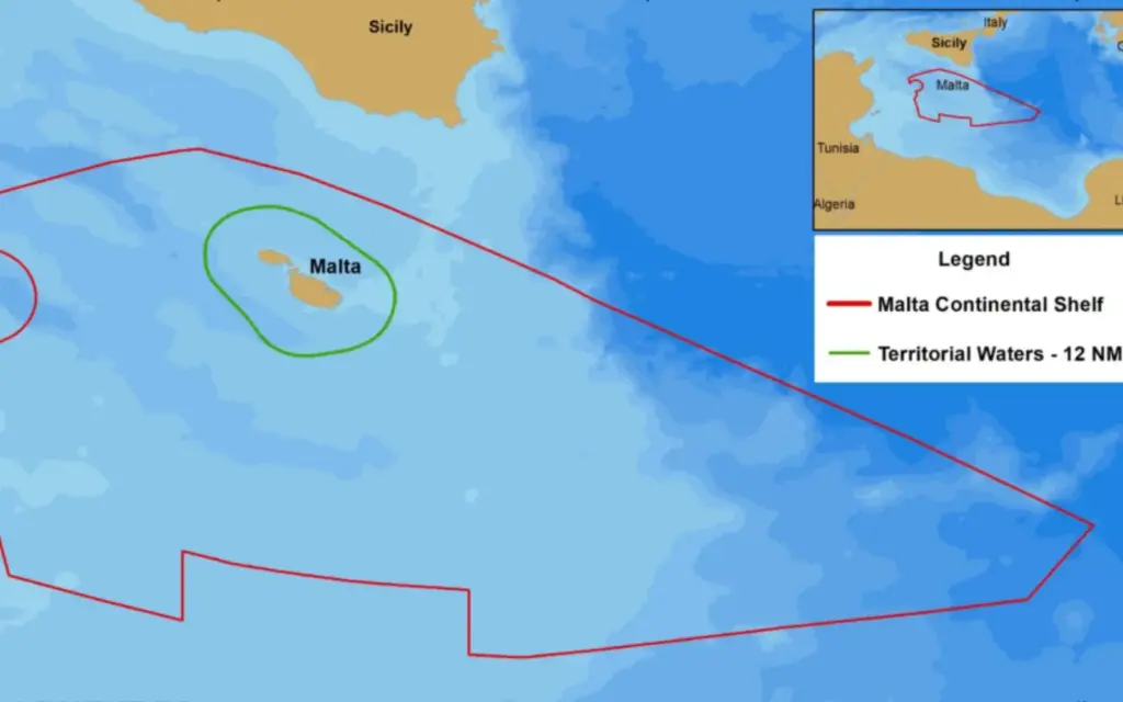
Legislation allows the government to designate an exclusive economic zone that coincides with the continental shelf, which is of similar size to the area used by the EU.
An EU dashboard, which also uses the 5.5% protected area coverage figure, specifies that the figures are provided to the European Environmental Agency by member states. This suggests Malta must and does submit the larger reference figure when reporting progress towards the EU’s 30% target.
Why is the Fisheries Management Zone area used locally?
One clue comes from a 2024 strategy document, which states that “Most of the laws of Malta currently only apply up to the territorial waters and therefore it is necessary to extend the applicability of certain laws to exclusive economic zone areas or environment protection areas”.
“The 35% figure is misleading if it’s meant to represent Malta’s total marine jurisdiction. The fisheries management zone is only a part of Malta’s seas,” says Jacob Armstrong, ocean policy manager at the World Wildlife Fund for Nature’s European Policy Office.
A spokesperson of the European Environmental Agency confirmed to Amphora Media that the area reported by Malta to the European Commission under various legal frameworks aimed at protecting Europe’s seas is indeed 75,715 km2 – the largest of the figures used, which is up to “200 NM [nautical miles] from the coast,” the spokesperson explained, which confirms that Malta uses this figure for EU frameworks.
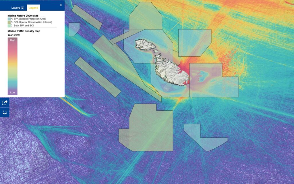
Data shows that some protected areas are criss-crossed by intensive vessel traffic, and environmental stress is likely despite protection. Protected habitats experience pressures from fishing, pollution and water sports activities. This is allowed in Natura 2000 sites, but must be monitored and managed.

Where Malta is free to choose the denominator, the extent of its marine protection coverage is correct. Malta uses FMZ coverage nationally and internationally, where it can formulate its own targets. However, this is somewhat arbitrary.
But for international accountability purposes, Malta’s “over 30% protected seas” claim is misleading.
By international standards, the figure is under 10%, and we did not find another European Mediterranean country calculating its protection coverage with a fisheries management zone or contiguous zone (similar size) as a denominator.
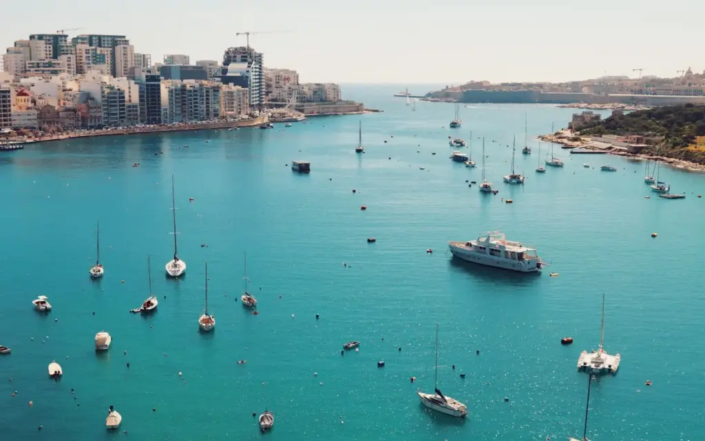
The FMZ is slightly larger than the contiguous zone and much smaller than the exclusive economic zone. It is a large area in comparison to Malta’s land mass, but it is not the area to consider when tracking Malta’s progress towards EU targets.
Since this portion of the Mediterranean Sea is assigned to Malta, no other country will step in to ensure protection. If Malta does not step up, it will leave gaps in Mediterranean protection coverage.
Flaunting the “more than 30%” figure, when the EU target is 30%, makes it look like Malta has already exceeded its EU commitment. However, according to international standards for calculating protected area coverage, Malta is far from fulfilling its commitment.
In this context specifically, the use of this figure to claim that Malta protects a large part of its seas is misleading.
This project is supported by the European Media and Information Fund. The sole responsibility for any content supported by the European Media and Information Fund lies with the authors and it may not necessarily reflect the positions of the EMIF and the Fund Partners, the Calouste Gulbenkian Foundation and the European University Institute.

